COMPASS AND MAP TOGETHER
The compass needle points to geographic North only at the agonic line (line of no declination because it is the same as the geographical North line). This line passes now through the west part of Florida and the Great Lakes. My friends in Wisconsin never have to adjust for magnetic declination. I hike and hunt in New York, where I have to adjust for 17 degrees West, and in Maine as much as 22 degrees West. The people on the West coast have to adjust for declination East.
If you are located over that line, the needle will point geographic North. All other times the magnetic needle points to the magnetic North that is located some 1300 miles from the geographic North.
Your topographic map will tell you in a diagram found in the left corner how much is the declination in your area. If the map is old, you may have to find the present declination to be more accurate in your traveling if it involves a long trek, where one degree could make a difference.
Once you found how many degrees of declination you have to adjust for, you can do it on the compass or on the map.
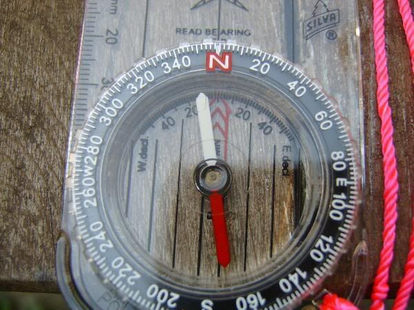
PICTURE OF A COMPASS WITH INSIDE DECLINATION SCALE
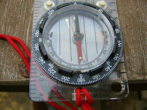
PICTURE OF A COMPASS WITH AN ADJUSTABLE SCALE, IT MOVES THE LOWER INSIDE DIAL
BY A GEARED SCREW.
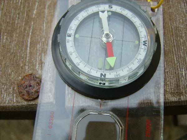
PICTURE OF A COMPASS WITHOUT A SCALE, IN THIS CASE YOU HAVE TO FIGURE YOUR DECLINATION BY ADDING OR SUBSTRACTING FROM THE 360 DEGREES, IN THIS CASE THE DECLINATION IS 18 WEST, SO THE NEEDLE IS PLACED OVER THE 342 MARKINGS.
EACH OF THE MARKINGS IS EQUIVALENT AT 2 DEGREES, THERE ARE 180 OF THEM AROUND THE COMPASS.
ADJUSTING THE MAP
To make the map speak compass language (magnetic North), extend the line of declination all across the map from the little diagram in the corner, using a long ruler and spacing the lines about two inches. Or use your compass as a protractor (measuring angles) to trace the start of the line from anywhere on the map.
After doing this, both the compass and the map will “speak” magnetic readings and you will not have to adjust the compass for magnetic declination.
ADJUSTING THE COMPASS
If you would rather adjust for declination on the compass (and save yourself from tracing lines on the map), every time you are going to follow a bearing in the field, you have to move the needle to the proper declination. So instead of pointing to North, it will point 22 degrees West of North (in the case of Maine), or 338 degrees.
Or, if you are West of the agonic line, then your declination will be East and you will have to move the needle East of the North marking on the compass.
Some compasses have a scale printed in the capsule, and some of them adjust by means of a internal rotating bezel that adjusts with a screwdriver stored in the lanyard. I like the latter type because there is nothing to do after you set it; you just place the needle in the “gate” that is already adjusted to the proper declination after you do it the first time.
To use the compass and map together, find where you are in the map and where you want to go, connect the two places with a line that extends from the side of your compass, and without moving it, rotate the “capsule” of the compass so that the lines inscribed on the bottom of the capsule combine with your drawn magnetic lines on the map OR the North line(s) or margin on the map if you are adjusting for declination on the compass.
Just follow the bearing that you have just set at the back end of the “line of travel arrow” and you will arrive at your destination.
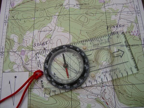
IN THIS PICTURE, A SUUNTOO S5SK IS USED TO CONNECT THE START AND FINISH, ONLY THING TO DO NOW IS ROTATE THE CAPSULE UNTIL THE LINES INSCRIBED IN IT, PARALLEL THE NORTH LINES ON THE MAP, AND READ THE DEGREES AT THE JUNCTION OF THE LINE OF TRAVEL ARROW AND THE BEZEL WITH THE NUMBERS. (DISREGARD THE MAGNETIC NEEDLE WHEN THE COMPASS IS ON THE MAP)
All this is very basic, but it will take you to the proper destination. If you would like to study map and compass a little more and learn how to navigate using more elaborate techniques, such as using handles, taking triangulation, or navigating in open terrain without the use of landmarks, I recommend you buy one of the books that are available on the subject.
I started many years ago with the classic “Be Expert with Map & Compass” by Bjorn Kjellstrom, which I recommend, but there are many other books that you can get from places like REI.
Using Map and Compass by Don Geary
The Outward Bound Map and Compass handbook by Glenn Randall
Wilderness Navigation by Bob and Mike Burns
I hope this little post can help someone interested in navigating the woods by map and compass. I feel that is a great need to go back to the basics to supplement and complement navigation with GPS, that after all, being electronic and depending on batteries can fail us when most needed.
All the best
Black Bear